
by Diego Morra
Before Ramon S. Ang floods the newspapers and broadcast stations, along with social media, with his sanctimonious orations about solving the country’s floods through his necessary dredging operations and lecturing from his lectern at the San Miguel Corp. (SMC) headquarters in Ortigas Center and his pompous plea for Filipinos to “change” for the better, reducing the basic problems of this country into cultural malaise, he should lose some hair by reading the pointed criticisms of his New Manila International Airport (NMIA) venture from UP coastal and marine geologist Dr. Fernando Siringan, who is the director of the Marine Science Institute (MSI) of the University of the Philippines Diliman (UP Diliman.)
Siringan’s essay, which was posted recently, said Ramon S. Ang’s NMIA is doing exactly the opposite of what a scientifically-based flood control program should do to shore up the low-lying areas of Bulacan and Pampanga. Ang talks of a comprehensive study that SMC, through the San Miguel Holding Corp. (SMHC) had commissioned to fully understand how it could protect its four-runway airport designed to handle a most optimistic figure of 100-million passengers. Ang is given to rosy projections and most-abstruse hype to promote his projects, but he cannot answer why the Philippine government did not think of transforming the farms and fishponds of Taliptip, Bulakan, Bulacan into a 2,500-hectare airport in the last 50 years. Neither can Ang debunk the study of the Japan International Cooperation Agency (JICA) that chose Sangley Point over Clark, Bulacan and Laguna de Bay as the site of an airport should the Ninoy Aquino International Airport (NAIA) be retired.
As government property, NAIA could be transformed into another concrete jungle of hotels, condominiums, casinos and other types of property development to be lapped up by dummies, mafia operators and global criminal syndicates. Knowing that the regime of Rodrigo Duterte gives short shrift to the environment, what with the unnecessary 32 huge reclamation projects being given the green light and his minions, reportedly including a largely-discredited lawmaker and another creature accused of complicity in the Pharmally scam, working to have those projects processed, Ang “labored” double-time since 2017 to develop his NMIA dream project that is covered by tax perks, and littered with dubious acquisitions of productive and submerged land, stretches of mangrove forests, and communities peopled by 300 families.
Siringan explains that far from the nice, little talking points churned out by Ramon S. Ang and his coterie of PR operators, the coastal plain of Pampanga, Bulacan and Camanava is an interconnected deltaic system where rivers, floodplains, wetlands, tidal channels, mangroves and Manila Bay work together to move, store and eventually discharge enormous volumes of water. In short, it is an integrated natural flood control system that, when blocked, pushes water into low-lying areas, which can be complicated by storm surges and land subsidence. Siringan says large-scale coastal development necessarily involves filling, elevating and converting portions of the very low-lying landscape that historically provided space for water. This defeats the natural flood storage function of the coastal plain and it would not restore any of the lost waterways and drainage pathways.
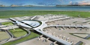
Siringan explains that the NMIA development has involved major alteration of the coastal landscape and drainage geometry. Whether the SMC calls it “reclamation” or development of existing fishpond land,” the hydraulic question remains: What happens to the water pathways that existed before the transformation? Ramon S. Ang cannot protect the wetlands and mangroves as the NMIA and the associated facilities in the Ang fiefdom are built precisely on a coastal environment containing wetlands, tidal flats, fishponds and other water-dependent ecosystems. Neither would it be possible to maintain tidal connectivity in the area. Building a huge elevated land platform and associated coastal infrastructure inevitably changes how water moves around it, Siringan argues.
Siringan and architect Nathaniel von Einsiedel, Pamalakaya, Bayan, Defend Manila Bay and the Kilusang Magbubukid ng Pilipinas (KMP) oppose NMIA, which they said could hardly contribute anything to controlling groundwater extraction and subsidence that characterize the area. Studies have shown that land subsidence in the Philippines is high. According to the paper “Ground subsidence in major Philippine metropolitan cities from 2014 to 2020” written by Jolly Joyce S. Sulapas, Audrei Anne B. Ybañez, Kayla Milcah M. Marasigan, Julian Marie Bernice M. Grageda and Alfredo Mahar Francisco A. Lagmay and carried by the International Journal of Applied Earth Observation and Geoinformation in September 2024, Bulacan registered the maximum subsidence rate of 109 mm/yr. It was 11 mm/yr in Metro Cebu, 38 mm/yr in Metro Davao, 9 mm/yr in Metro Iloilo and 29 mm/yr in Legazpi City. “Sinking areas mostly coincide with industrial and commercial complexes evident as a contiguous distribution of large and expansive man-made structures with distinct radar reflections,” the paper argued. It was the first study on land subsidence in the Philippines.
The 2024 study urged that monitoring subsidence especially in Bulacan is crucial as subsidence raises the risks of floods, building and infrastructure damage, and economic loss, and exposes residents along the coast to worsening tidal incursions and storm surges due to climate change. Siringan, who has written extensively for the same journal in more than 23 years, suggested that a targeted, long-term deformation monitoring tool, especially related to groundwater usage, must be implemented. In the case of Ramon S. Ang’s NMIA, what his company is doing is exactly the opposite of what should be done. Putting massive infrastructure and additional development on an already extremely low-lying, subsidence-prone coastal plain, he asserted, creates a fundamental engineering challenge: How do you keep the land—and the drainage system— functioning as the surrounding area rises and the ground continues to shrink?
NMIA must restore cross-flow and natural drainage in the area. Yet, roads, embankments, airport platforms, dikes and other elevated structures can become barriers when they interrupt natural drainage pathways or lack sufficient hydraulic openings. Neither could the airport increase flood storage. Replacing natural landscapes with hardened, engineered surfaces generally means less natural storage and more rapid runoff. Finally, Siringan declared: You cannot solve a delta’s flood problem by treating the delta as empty land. “The airport may have a project boundary. The water does not. The airport may have an engineering model. The delta does not operate according to the project boundary. Water from upstream watersheds eventually reaches the coastal plain. Tides push inland. Storm surges push water landward. Subsidence lowers the land. Rainfall generates runoff. Rivers attempt to discharge into Manila Bay. Everything is connected,” he said. “Does the entire interconnected delta remain hydraulically functional and safe after this massive transformation of its coastal landscape?” Siringan asked Ang.#