📷: Mall of Asia (guidetothephilippines.ph)
by Diego Morra
Science has a way of botching insatiable greed, like the unmatched lust of plutocrats and business conglomerates for reclamation, like the projects to steal as much land from the sea to build residential and office condominiums, casinos, hotels and “environmental zones” as salve to the consciences of those who have been destroying the environment in the guise of development and progress.
Include in this rogues’ gallery those who kicked out farmers and fishermen in Bulakan, for the construction of the so-called New Manila International Airport (NMIA), a 2,500-hetcare enclave of Ramon and Ang and his principals, with four runways, a racing course for Ferrari, Lamborghini and Maserati lovers, as well as facilities for San Miguel Corp. (SMC) and scores of its affiliates and subsidiaries. Now, the moneybags who crafted the 32 reclamation ventures in Manila Bay must now confront the reality that the more they reclaim, the more the land they stole from the sea sinks.
Reclamation is not merely an engineering issue and brilliant engineers, like the late F. F. Cruz, have been wont to say that construction problems always have solutions. Apparently, the environment can also pose significantly serious problems that even topnotch engineers cannot solve. The problem of Kansai Airport illustrates just how nature can ruin the best airport designs. The airport, built over reclaimed land off Osaka to reduce noise and guarantee longer sleeping times for elderly and young Japanese, is sinking. In Ramon Ang’s NMIA project, Boskalis has been contracted to conduct seabed quarrying in 2,500 hectares of the seabed in several Cavite towns, Another contract covers a similar seabed hectarage for the benefit of Ang’s airport. The marine sediments are meant for the SMC reclamation project, not some “land improvement” activity.
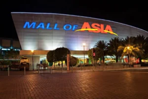
On Feb. 10, 2026, the Office of the Vice President for Academic Affairs of the University of the Philippines (UP) released a report on a study conducted by UP on ground subsidence in the Manila Bay Freeport Zone using satellite-based measurements from January 2018 to December 2021. Entitled “Ground Deformation Monitoring of Reclaimed Lands Along Manila Bay Freeport Zone Using PS-InSAR Technique,” the study looked into the Bay City using 119 Sentinel-1 radar satellite images for both ascending and descending tracks. Researchers from the UP Department of Geodetic Engineering used Persistent Scatterer Interferometric Synthetic Aperture Radar (PS-InSAR), a technique capable of detecting millimeter-level vertical land movement. The study focuses on the Manila Bay Freeport Zone, the country’s largest reclamation project and the site of the SM Mall of Asia and other key establishments in its vicinity.
Across the area, the mean vertical velocity rate was -2.06 ± 2.84 mm per year, indicating an overall downward movement. Nonetheless, most of the Manila Bay Freeport Zone remains relatively stable, with subsidence occurring in localized clusters rather than across the entire reclaimed land. At the CCP–Financial Center Area (CCP-FCA), 20 subsiding points were detected, with the average vertical velocity rate at -0.73 ± 1.82 mm/year. Seascape Village recorded the highest localized average subsidence rate at -8.22 mm/year. “Upon closer inspection, it was discovered that the southernmost section of the recently-built region is comprised of high-rise buildings situated roughly 50 meters away from Seascape Village. This can be attributed to the detected localized subsidence in the nearby area,” the study said. These high-rises caused the sinking.
At the Central Business Park I-A (CBP-IA), 31 subsiding points out of 1,634 were found to be sinking at the average vertical velocity rate of -1.61 ± 1.64 mm/year. A cluster in the southwest section recorded significant subsidence averaging 9.69 mm/year. “Cracks on cemented structures, sidewalks, and restaurant walls were seen in the area where a cluster of subsiding points is located,” the researchers said. At the Central Business Park IB & IC (CBP-IB & IC), the study noted 35 subsiding points out of 690, with the average vertical velocity rate at -2.53 ± 2.32 mm/year.
“A total of 4 subsiding points around Caltex station were detected with the lowest velocity rate of -17.52 mm/yr. It is important to note that the road adjacent to the store is unpaved. Unpaved roads are susceptible to deformation,” the study said. “This kind of road is also prone to erosion by wind or water, which can lead to further deformation. Similarly, a few cracks and gaps were observed on each side of the bridge across the station.” To validate the findings, researchers compared satellite results with annual leveling data from benchmarks near the Port of Manila. The correlation between PS-InSAR measurements and leveling data ranged from 0.81 to 0.96, indicating a strong positive linear relationship and reinforcing the reliability of the satellite technique.
The UP study said reclaimed lands are composed of unconsolidated marine sediments such as silt and sand. Over time, these materials naturally compact under their weight and under additional load from buildings and infrastructure. Construction activity induces localized differential settlement. The researchers warn that subsidence increases the exposure to coastal hazards such as flooding and storm surges. Ground deformation on reclaimed lands is expected to continue and recommend monitoring to identify areas with significant deformations, detect building and structural deformations, and find solutions to reduce the risk of environmental hazards.